(NEW YORK) — Hurricane Erin, now a powerful Category 4 storm churning in the Caribbean, is not forecast to hit land, but it will bring large waves and dangerous rip currents to the U.S. East Coast.
Here’s the latest forecast:
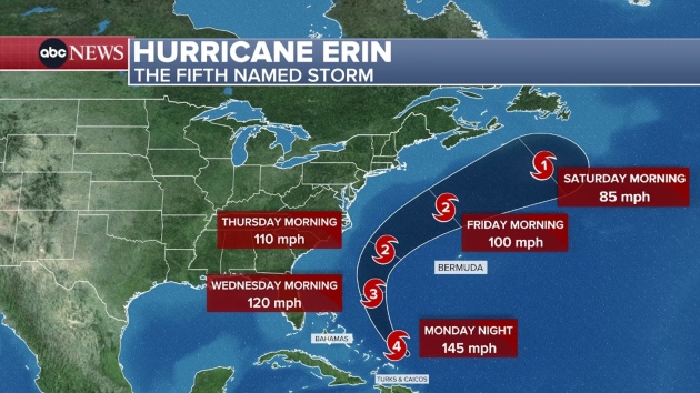
Erin’s outer bands lashed the Caribbean this weekend, flooding Puerto Rico and leaving more than 60,000 customers on the island without power on Monday.
A tropical storm warning is in place for the Turks and Caicos Islands and part of the Bahamas, where winds could top 40 mph.
While Erin won’t hit the U.S., lifeguards along the East Coast are on alert for dangerous waves and rip currents this week.
On Monday and Tuesday, Erin will bring large waves reaching 6 feet to the East Coast. Waves over 6 feet are considered extremely dangerous for swimmers.
By Wednesday, those waves could reach 8 to 12 feet in northern Florida and from Myrtle Beach, South Carolina, up to the Outer Banks of North Carolina.
On Thursday, those 8- to-12-foot waves will remain in the Outer Banks and could also target New Jersey and Long Island beaches.
By Friday, waves are expected to weaken back to 6 feet as Erin takes a sharper turn away from the U.S.
Dangerous rip currents will also be widespread along the East Coast all week, and likely through the weekend, due to these unsettled waters.
Copyright © 2025, ABC Audio. All rights reserved.